
Gen3dlife Journals Results
Solar simulation for 3D city models may be a complex task if detailed geometry is taken into account. For this reason, the models are often approximated by simpler geometry to reduce their size and complexity. However, geometric details, as for example the ones that exist in a roof, can significantly change the simulation results if not properly taken into account. The classic solution to deal with a too detailed city model is to use a Level-of-Detail (LoD) approach for geometry reduction.
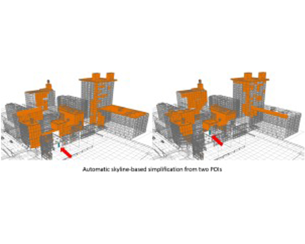
In this paper we present a new LoD strategy for 3D city models aimed at accurate solar simulations able to cope with models with highly detailed geometry. Given a Point of Interest (POI) or a Region of Interest (ROI) to analyze, the method works by automatically detecting and preserving all the geometry (i.e., roofs) that have significant impact on the simulation and simplifying the rest of the geometry.

IEEE Transactions on Visualization and Computer Graphics, Vol. 24, Num. 12, pp 3239--3252, 2018.
DOI: http://dx.doi.org/10.1109/TVCG.2018.2794526
DOI: http://dx.doi.org/10.1109/TVCG.2018.2794526
BibTeX
Weathering effects are ubiquitous phenomena in cities. Buildings age and deteriorate over time as they interact with the environment. Pollution accumulating on facades is a particularly visible consequence of this. Even though relevant work has been done to produce impressive images of virtual urban environments including weathering effects, so far, no technique using a global approach has been proposed to deal with weathering effects. Here, we propose a technique based on a fast physically-inspired approach, that focuses on modeling the changes in appearance due to pollution soiling on an urban scale. We consider pollution effects to depend on three main factors: wind, rain and sun exposure, and we take into account three intervening steps: deposition, reaction and washing. Using a low-cost pre-computation, we evaluate the pollution distribution throughout the city. Based on this and the use of screen-space operators, our method results in an efficient approach able to generate realistic images of urban scenes by combining the intervening factors at interactive rates. In addition, the pre-computation demands a reduced amount of memory to store the resulting pollution map and, as it is independent from scene complexity, it can suit large and complex models by adapting the map resolution.
A technique for massive sky view factor calculations in large cities
International Journal of Remote Sensing, Vol. 39, Num. 112, pp 4040--4058, 2018.
DOI: http://dx.doi.org/10.1080/01431161.2018.1452071
DOI: http://dx.doi.org/10.1080/01431161.2018.1452071
BibTeX
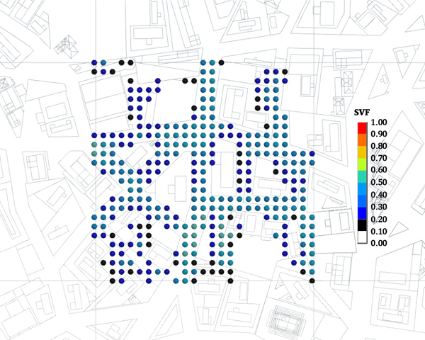
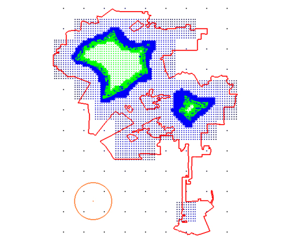
In many applications, such as urban physics simulations or the study of the solar impact effects at different scales, complex 3D city models are required to evaluate physical values. In this article, we propose an efficient system for quickly computing the Sky View Factor (SVF) for a massive number of points inside a large city. To do that, we embed the city into a regular grid, and for each cell we select a subset of the geometry consisting of a square area centred in the cell and including it. Then, we remove the selected geometry from the city model and we project the rest onto a panoramic image, called environment map. Later, when several SVF evaluations are required, we only need to determine the cell that each evaluation point belongs to, and compute the SVF with the cell’s geometry plus its corresponding environment map. To test our system, we perform several evaluations inside a cell’s area, and compare the results with an accurate ray-tracing-based SVF evaluation. Our results show the feasibility of the method and its advantages when used for a large set of computations. We show that our tool provides a way to handle the complexity of urban scale models, and specifically allows working with geometry details if they are required.
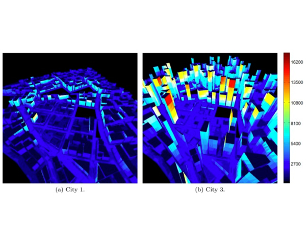
Cities numerical simulation including physical phenomena generates highly complex computational chal- lenges. In this paper, we focus on the radiation exchange simulation on an urban scale, considering differ- ent types of cities. Observing that the matrix representing the view factors between buildings is sparse, we propose a new numerical model for radiation computation. This solution is based on the radiosity method. We show that the radiosity matrix associated with models composed of up to 140k patches can be stored in main memory, providing a promising avenue for further research. Moreover, a new technique is proposed for estimating the inverse of the radiosity matrix, accelerating the computation of radiation exchange. These techniques could help to consider the characteristics of the environment in building de- sign, as well as assessing in the definition of city regulations related to urban construction.
A Perspective on procedural modeling based on structural analysis
Virtual Archaeology Review, Vol. 8, Num. 16, pp 44--50, 2017.
DOI: http://dx.doi.org/10.4995/var.2017.5765.
DOI: http://dx.doi.org/10.4995/var.2017.5765.
BibTeX
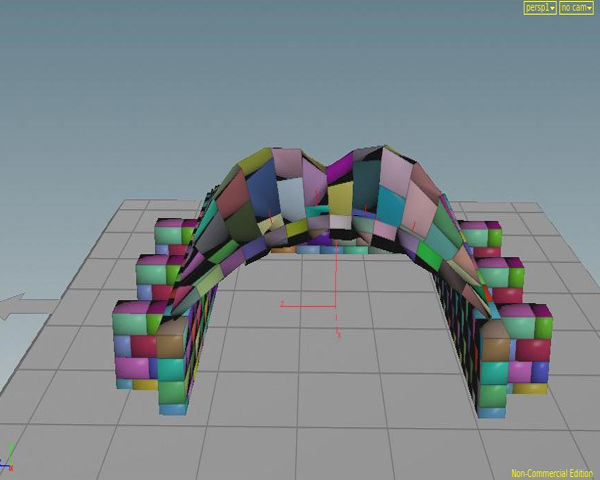
With the rise of available computing capabilities, structural analysis has recently become a key tool for building assessment usually managed by art historians, curators, and other specialist related to the study and preservation of ancient buildings. On the other hand, the flourishing field of procedural modeling has provided some exciting breakthroughs for the recreation of lost buildings and urban structures. However, there is a surprising lack of literature to enable the production of procedural-based buildings taking into account structural analysis, which has proven to be a crucial element for the recreation of faithful masonry structures. In order to perform an in-depth study of the advances in this type of analysis for cultural heritage buildings, we performed a study focused on procedural modeling that make use of structural analysis methods, especially in its application to historic masonry buildings such as churches and cathedrals. Moreover, with the aim of improving the knowledge about structural analysis of procedurally-recreated historical buildings, we have taken a geometric structure, added a set of procedural walls structured in masonry bricks, and studied its behavior in a generic, freely-available simulation tool, thus showing the feasibility of its analysis with non-specialized tools. This not only has allowed us to understand and learn how the different parameter values of a masonry structure can affect the results of the simulation, but also has proven that this kind of simulations can be easily integrated in an off-the-shelf procedural modeling tool, enabling this kind of analysis for a wide variety of historical studies, or restoration and preservation actions.
Intersecting two families of sets on the GPU
Journal of Parallel and Distributed Computing, 2017.
DOI: http://dx.doi.org/10.1016/j.jpdc.2017.01.026
DOI: http://dx.doi.org/10.1016/j.jpdc.2017.01.026
BibTeX
The computation of the intersection family of two large families of unsorted sets is an interesting problem from the mathematical point of view which also appears as a subproblem in decision making applications related to market research or temporal evolution analysis problems. The problem of intersecting two families of sets F and F′ is to find the family I of all the sets which are the intersection of some set of F and some other set of F. In this paper, we present an efficient parallel GPU-based approach, designed under CUDA architecture, to solve the problem. We also provide an efficient parallel GPU strategy to summarize the output by removing the empty and duplicated sets of the obtained intersection family, maintaining, if necessary, the sets frequency. The complexity analysis of the presented algorithm together with experimental results obtained with its implementation is also presented.
A Fast Daylighting Method to Optimize Opening Configurations in Building Design
Energy and Buildings, Vol. 125, Num. 1, pp 205--218, 2016.
DOI: http://dx.doi.org/10.1016/j.enbuild.2016.05.012
DOI: http://dx.doi.org/10.1016/j.enbuild.2016.05.012
BibTeX
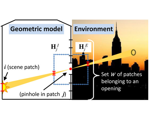
Daylighting plays a very important role for energy saving in sustainable building, therefore, setting the optimal shapes and positions of the openings is crucial for daylighting availability. On the other hand, computing daylighting for climate-based data is a time-consuming task involving large data set and is not well suited for optimization approaches. In this paper we propose a new and fast daylighting method that allows to perform opening shape optimizations. The base of our method is to model each element of an opening surface as a pinhole and then formulate a compact irradiance-based representation to ease global illumination calculations. We use the UDI metric to evaluate our method, on an office-based model, for different orientations and different geographical locations, showing that optimal windows shapes can be obtained in short times. Our method also provides an efficient way to analyze the impact of climate-based data on the shape of the openings, as they could be modified interactively.
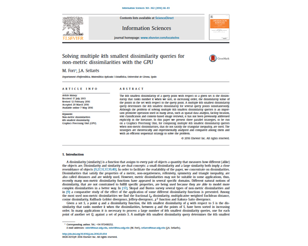
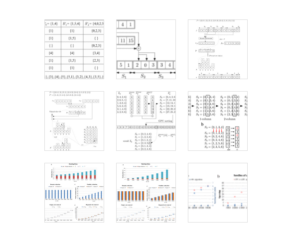
Solving multiple kth smallest dissimilarity queries for non-metric dissimilarities with the GPU
Information Sciences, Vol. 361, pp 66-83, 2016.
DOI: http://dx.doi.org/10.1016/j.ins.2016.03.054
DOI: http://dx.doi.org/10.1016/j.ins.2016.03.054
BibTeX
The kth smallest dissimilarity of a query point with respect to a given set is the dissimilarity that ranks number k when we sort, in increasing order, the dissimilarity value of the points in the set with respect to the query point. A multiple kth smallest dissimilarity query determines the kth smallest dissimilarity for several query points simultaneously. Although the problem of solving multiple kth smallest dissimilarity queries is an important primitive operation used in many areas, such as spatial data analysis, facility location, text classification and content-based image retrieval, it has not been previously addressed explicitly in the literature. In this paper we present three parallel strategies, to be run on a Graphics Processing Unit, for computing multiple kth smallest dissimilarity queries when non-metric dissimilarities, that do not satisfy the triangular inequality, are used. The strategies are theoretically and experimentally analyzed and compared among them and with an efficient sequential strategy to solve the problem.
Information Systems, Vol. 62, pp 136-154, 2016.
DOI: http://dx.doi.org/10.1016/j.is.2016.07.003
DOI: http://dx.doi.org/10.1016/j.is.2016.07.003
BibTeX
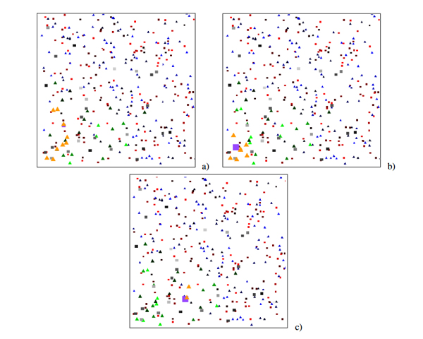
In this paper we propose, motivate and solve multiple bichromatic mutual nearest neighbor queries in the plane considering multiplicative weighted Euclidean distances. Given two sets of facilities of different types, a multiple bichromatic mutual (k,k′)-nearest neighbor query finds pairs of points, one of each set, such that the point of the first set is a k -nearest neighbor of the point of the second set and, at the same time, the point of the second set is a k′-nearest neighbor of the point of the first set. These queries find applications in collaborative marketing and prospective data analysis, where facilities of one type cooperate with facilities of the other type to obtain reciprocal benefits. We present a sequential and a parallel algorithm, to be run on the CPU and on a Graphics Processing Unit, respectively, for solving multiple bichromatic mutual nearest neighbor queries. We also present the time and space complexity analysis of both algorithms, together with their theoretical comparison. Finally, we provide and discuss experimental results obtained with the implementation of the proposed sequential and a parallel algorithm.
Gen3dlife Conferences Results
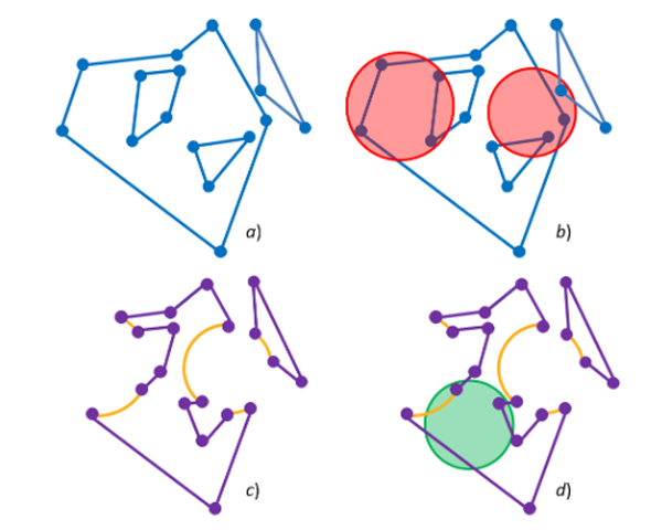
Computing the maximum overlap of a disk and a piecewise circular domain under translation
European Workshop on Computational Geometry (EuroCG), 2016.
BibTeX
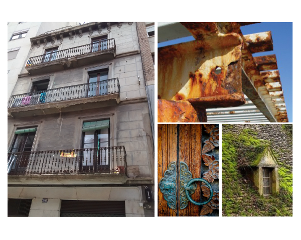
In this paper, we propose to discuss on one of the main challenges in realistic rendering of urban scenes: changes in appearance over time within a urban context. After studying the previous work on weathering techniques, we have found that there is a lack of estimation for some important environmental parameters (such as sun radiation) that have a wrong impact on weathering phenomena simulation and, thus, on the appearance of virtual objects. We also think that such a problem needs to be addressed on large urban models. Here, we discuss some possible solutions we have studied in our research. These solutions are focused on screen-space techniques, in order to efficiently compute those factors and use them to interactively generate weathering effects.
Commercial Evolution Simulation
Eurographics Workshop on Urban Data Modelling and Visualization, UDMV, pp 59-64, 2015.
DOI: http://dx.doi.org/10.2312/udmv20151351
DOI: http://dx.doi.org/10.2312/udmv20151351
BibTeX
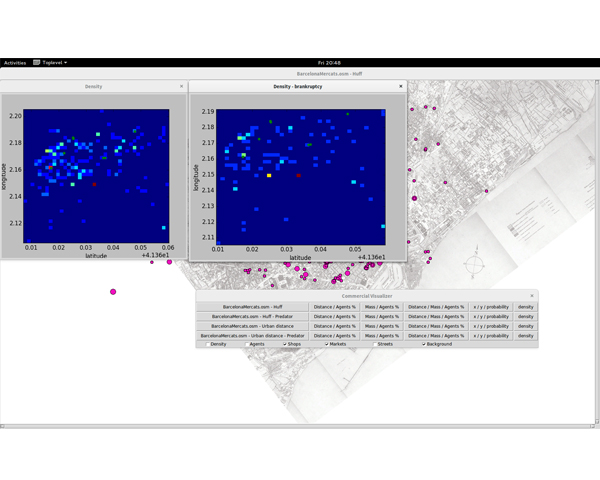
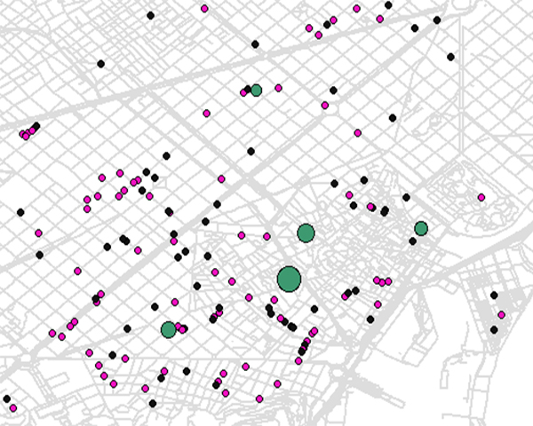
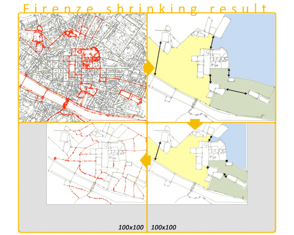
Simulating the evolution of urban landscapes is a challenging objective with a large impact not only for Computer Graphics (for its applications in the filming and gaming industries), but also for urban planning, economical and historical studies, urban physics, and many other. However, this target has remained elusive because of the large complexity implied by urban structures and their evolutions. We present a system that aims at simulating the evolution of the commercial structure in a modern city. In particular, given an initial distribution of shops, it studies the evolution when larger commercial areas, like malls, are introduced. This is computed using the Huff model as a measure of the attraction each commerce has on potential consumers, and an agent-based simulation to determine how these aspects affect their choices. Then, after a given simulation time, the system decides whether the shop has retained an income such that it can continue operating, or has gone bankrupt. Our system is used to study the evolution of the commercial structure of Barcelona city over the last century.
Simulation of the commercial market evolution in a city
Spanish Computer Graphics Conference (CEIG), pp 103-107, 2015.
DOI: http://dx.doi.org/10.2312/ceig.20151206
DOI: http://dx.doi.org/10.2312/ceig.20151206
BibTeX
Simulating the evolution of urban landscapes is a challenging objective with a large impact not only for Computer Graphics (for its applications in the filming and gaming industries), but also for urban planning, economical and historical studies, urban physics, and many other. However, this target has remained elusive because of the large complexity implied by urban structures and their evolutions. We present a system that aims at simulating the evolution of the commercial structure in a modern city. In particular, given an initial distribution of shops, it studies the evolution when larger commercial areas, like malls, are introduced. This is computed using the Huff model as a measure of the attraction each commerce has on potential consumers, and an agent-based simulation to determine how these aspects affect their choices. Then, after a given simulation time, the system decides whether the shop has retained an income such that it can continue operating, or has gone bankrupt. Our system is used to study the evolution of the commercial structure of Barcelona city over the last century. 1. Introduction Procedural urban modeling has presented us with astonishing results over the last decade, starting with the seminal work by Parish and Muller [PM01] and Muller et al. [MWH 06], and continuing with the recent advances in acquisition [MWA 12], non-regular modeling [LCOZ 11], user interfaces [Pat12], among others. However, in spite of all those improvements, several problems remain open [PBP14], one of the most important ones is simulating the evolution of urban landscapes over time. With only a few exceptions [WMWG09,BWK14], this topic has barely been touched, in spite of its crucial importance for history and archeology, urban planning, socio-economical studies, and many other social-related disciplines. Among these unexplored aspects, the problem of simulating the evolution of the commerce structure in a city is a prominent one, as it is attractive for being computationally tractable and crucial for socio-economic studies. But this study has applications that are broader than a pure social analysis, as the resulting distributions can be used to also model its appearance over time, which is interesting for computer graphics because of its applications to film and videogames, two of the leading industries in the field
Computing the maximum overlap of a disk and a polygon with holes under translation
Actas XVI Encuentros de Geometría Computacional, Barcelona, 2015.
BibTeX
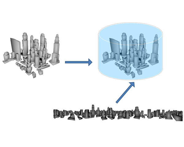
In many applications, such as in urban physical simulations or in the study of the effect of the solar impact at different scales, models with different levels of detail are required. In this paper we propose an efficient system for quickly computing the Sky View Factor (SVF) for any point inside a large city. To do that, we embed the city into a regular grid, and for each cell we select a subset of the geometry consisting of a square area centered on the cell and including it. Then, we remove the selected geometry from the city model and we project the rest onto a panoramic image (in our case, the sides of a box). Later, when several SVF evaluations are required, we only need to determine the cell that the evaluation point belongs to, and compute the SVF with the cells geometry plus the environment map. To test our system, we perform several evaluations inside a cells area, and compare the results with the ground truth SVF evaluation. Our results show the feasibility of the method and its advantages when used for a large set of computations. We show that our tool provides a way to handle the complexity of urban scale models, and specifically to study the sensitivity of the geometry.
Easy going vector graphics as textures on the GPU
Spanish Computer Graphics Conference (CEIG), pp 91 - 94, 2015.
DOI: http://dx.doi.org/10.2312/ceig.20151204
DOI: http://dx.doi.org/10.2312/ceig.20151204
BibTeX
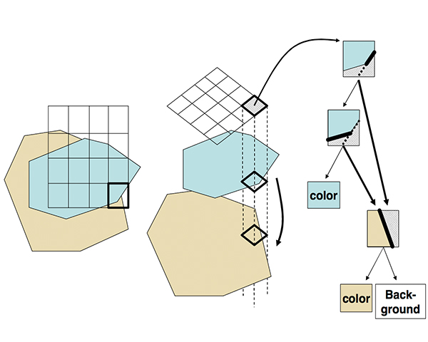
One common problem of raster images when used as textures is its resolution dependence, which could produce artifacts such as blurring. On the contrary, vector graphics are resolution independent, and their direct use for real-time texture mapping would be desirable to avoid sampling artifacts. Usually, they composite images from layers of paths and strokes defined with different kinds of lines. Here I present a simple yet powerful technique for representing vector graphics as textures that organizes the graphic into a coarse grid of cells, structuring each cell into simple cell-sized BSP trees, evaluated at runtime within a pixel shader. Advantages include coherent low-bandwidth memory access and, although my implementation is limited to polygonal shapes, the ability to map general vector graphics onto arbitrary surfaces. A fast construction algorithm is presented, and the space and time efficiency of the representation are demonstrated on many practical examples.
Gen3dlife PhD Thesis Results
Realistic Urban Layout Modeling from Real Data
PhD. Thesis. January 2016.
Advisors: Patow, Gustavo A.
BibTeX
High Dynamic Range Content Acquisition from Multiple Exposures
PhD. Thesis. January 2016.
Advisors: Martín, Ignacio
BibTeX